Signal No. 4 still up in Batanes as Super Typhoon Leon approaches
MANILA, Philippines — Super Typhoon Leon (international name: Kong-Rey) maintained its strength as it continues to move closer to Batanes islands, with Tropical Cyclone Wind Signal No. 4 still hoisted over the area, said the Philippine Atmospheric Geophysical Astronomical Services Administration (Pagasa).
According to the state weather bureau, Leon was last spotted 215 kilometers east southeast of Basco, Batanes as of 4 p.m.
It continues to carry maximum sustained winds of 185 kilometers per hour (kph) and gustiness of up to 230 kph while moving northwestward at 20 kph.
“Leon will be closest to Batanes from late evening today to tomorrow morning. A landfall in Batanes is also not ruled out,” Pagasa said in its 5 p.m. typhoon bulletin.
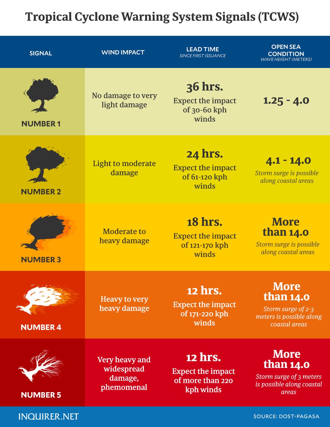
Still at Signal No. 4 is Batanes, which means typhoon-force winds or winds exceeding 118 kph up to 184 kph may be expected in at least 12 hours causing significant to severe impacts.
Article continues after this advertisement
Pagasa said Signal No. 5 may also be hoisted over Batanes should Leon veer to the left of its forecast track.
Article continues after this advertisement

Below are the other areas currently under Signals No. 1 to 3:
Signal No. 3 (storm-force winds with speeds reaching 89 kph up to 117 kph may be in the next 18 hours)
- The eastern portion of Babuyan Islands (Babuyan Is., Camiguin Is., Calayan Is.,) and
- The northeastern portion of mainland Cagayan (Santa Ana)
Signal No. 2 (gale-force 62 kph up to 88 kph in speed expected within 24 hours)
- The rest of Babuyan Islands,
- The rest of mainland Cagayan,
- The northern portion of Isabela (Santo Tomas, Santa Maria, Quezon, Delfin Albano, San Pablo, Ilagan City, Tumauini,
- Cabagan, Palanan, Quirino, Divilacan, Mallig, Maconacon, Gamu, Burgos, Roxas, San Mariano, Reina Mercedes, San Manuel, Naguilian, Benito Soliven)
- Apayao
- Kalinga
- The northern and eastern portions of Abra (Tineg, Lacub, Malibcong, Lagayan, San Juan, Lagangilang, Licuan-Baay, Daguioman)
- The eastern portion of Mountain Province (Paracelis) and
- Ilocos Norte
Signal No. 1 (strong winds 39 to 61 kph in speed expected within 36 hours)
- The rest of Isabela
- Quirino
- Nueva Vizcaya
- The rest of Mountain Province
- Ifugao
- Benguet
- The rest of Abra
- Ilocos Sur
- La Union
- Pangasinan
- Nueva Ecija
- Aurora and
- The northeastern portion of Tarlac (Camiling, San Clemente, Paniqui, Moncada, Anao, San Manuel, Pura, Ramos, Victoria, Gerona, Santa Ignacia, City of Tarlac, La Paz)
READ: LIVE UPDATES: Severe Tropical Storm Leon
Meanwhile, despite mostly affecting the northern portions of Luzon, Pagasa said strong to gale-force winds may also occur over Bataan, Metro Manila, Calabarzon, Mimaropa, Bicol Region, most of Visayas and Dinagat Islands due to Leon’s wind flow or the direction of its prevailing winds.